Scotland’s Oldest Bridges.
A map-based catalogue of the oldest masonry bridges in Scotland.
TUVWY - Alphabetical List
TAY BRIDGE Aberfeldy
C.Perth R.Tay 285127,749299
History:1733-35. Military. Wade. Crieff/Dalnacardoch Rd. This was Wade's masterpiece. It was designed by William Adam, whom Wade described as the best architect in Scotland. Wade regarded the bridge as a prestige symbol and a lasting memorial. He was right! It looks as as if it belongs to an expensive country estate. It was completed in a single year(1734) and cost £4095 . Wade had considered a major bridge at Dunkeld in order to cross the Tay, but fell out with the Duke of Atholl and so chose Aberfeldy instead. Stone was quarried at Farrowchil, one mile away. The Weem Hotel, on the north bank of the river, was originally a barracks for his workers. Major William Caulfeild supervised the finishing of the bridge but Wade was brought back for the grand opening in 1735. In 1746, Prince Charles' army retreated over the bridge with Cumberland's troops in hot pursuit. The Battle of Culloden was just a few weeks away.
Maps:1750
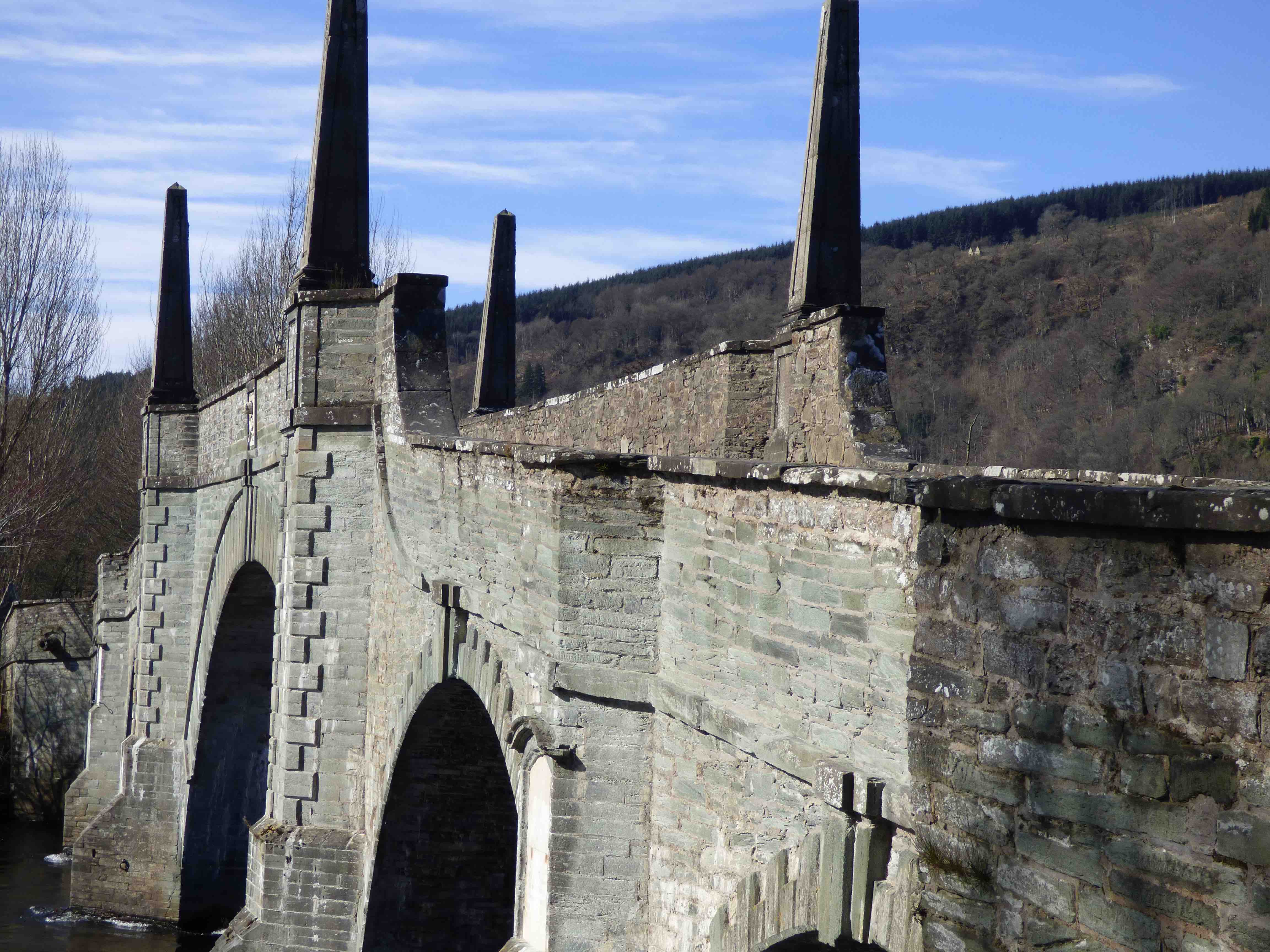
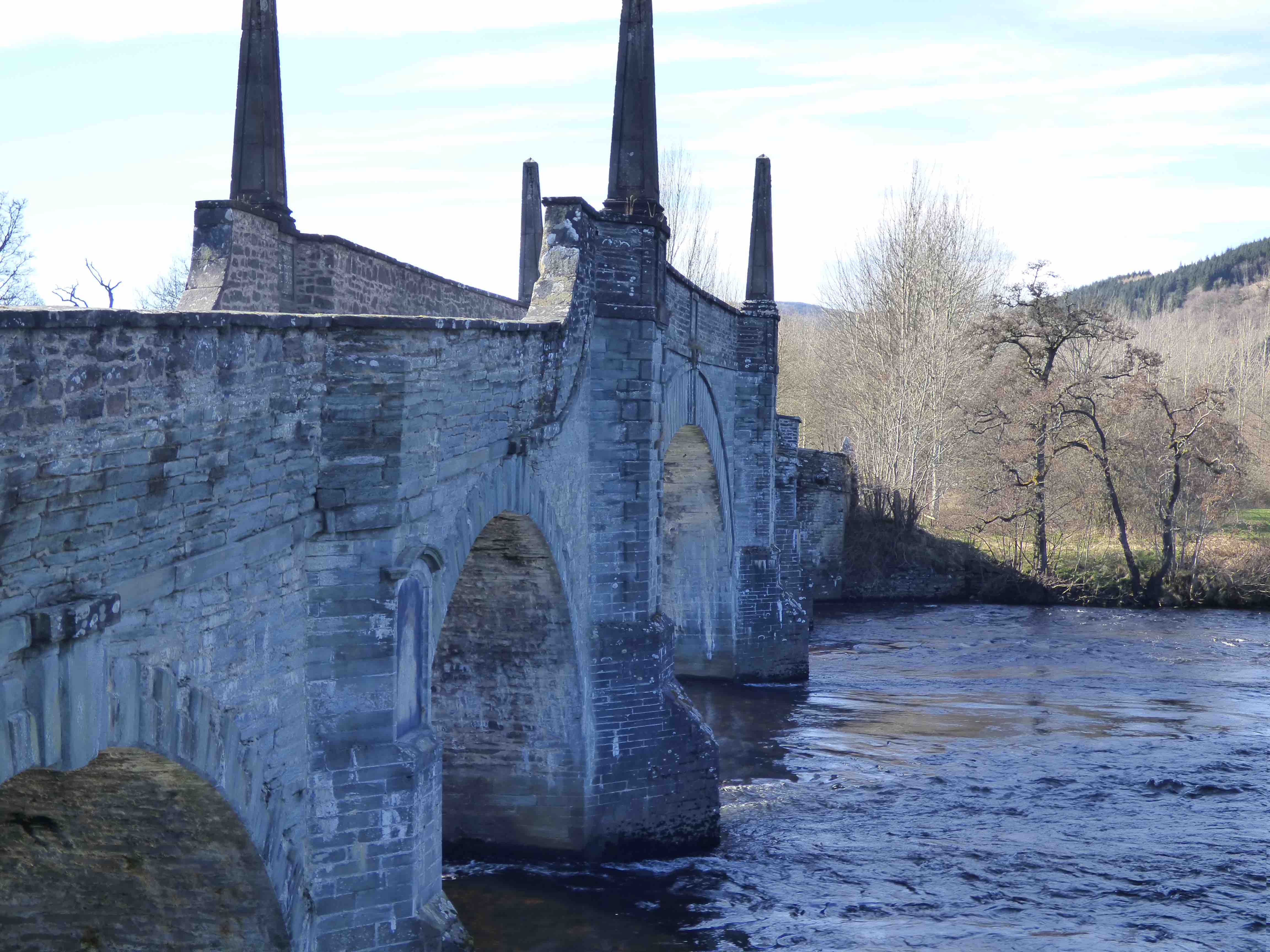
Currently: 1733.This is the most elaborate of the eighteenth century military bridges and quite atypical. It is a classic William Adam construction. The foundations are underpinned by 1200 oak piles, encased in iron. There are five segmental arches; centre 62ft; then two sets of pairs. It is 368 ft. long. and 14 ft. wide. It has very large ashlar voussoirs and squared coursed rubble spandrels and abutments. The stone is chorite schist. There are obelisks at each quarter and unusual stepped parapets descend to the lesser arches. There are two inscriptions, one in English, which is very matter-of-fact, and one in Latin, which is very flowery in style.
_______________________________________________
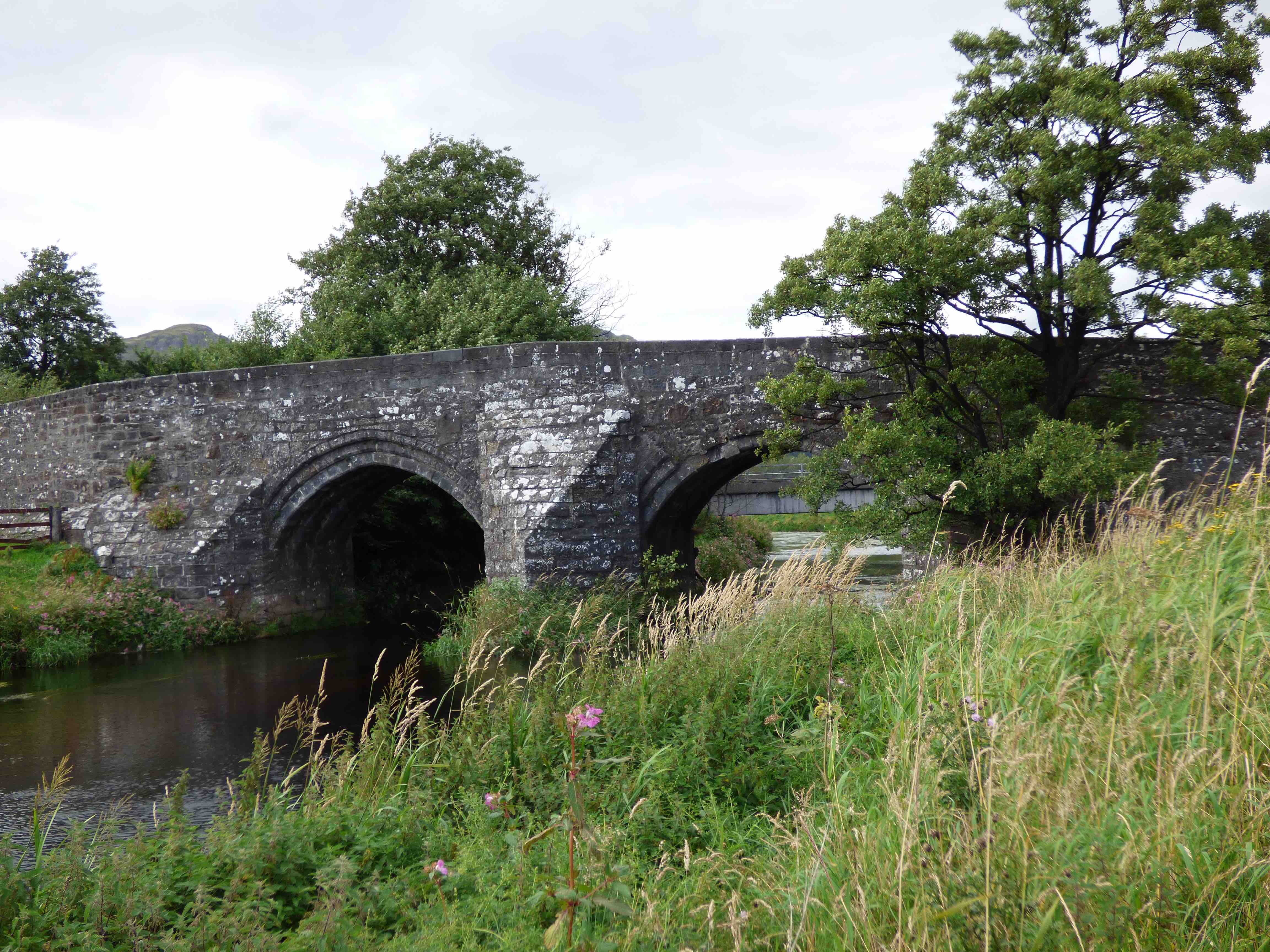
TEITH BRIDGE Doune
C.Stirling R.Teith 272176,701232
History: 1535: inscription appears original. Built by Robert Spittal, tailor to Queen Margaret Tudor. (Spittal is also reputed to have built Tullibody Bridge and Bannockburn Bridge.) The bridge was a key component of an ancient north/south route which bypassed Stirling by way of the Fords at Frew. In 1715, it was‘destroyed’ (probably, one arch was cut) by the Earl of Argyll in order to force the Jacobite army to take the Stirling approach from Perth; the battle of Sherrifmuir may have been a consequence. In the’45 Rebellion the Highland army crossed it both in advance and in retreat. The bridge was later part of Caulfield's military road of 1752 from Stirling to Inverness. The road became a turnpike in 1812. The bridge was widened in 1866. Old and New Statistical Accounts contain descriptions of its provenance.
Maps:1750(Roy) 1680s(Adair)
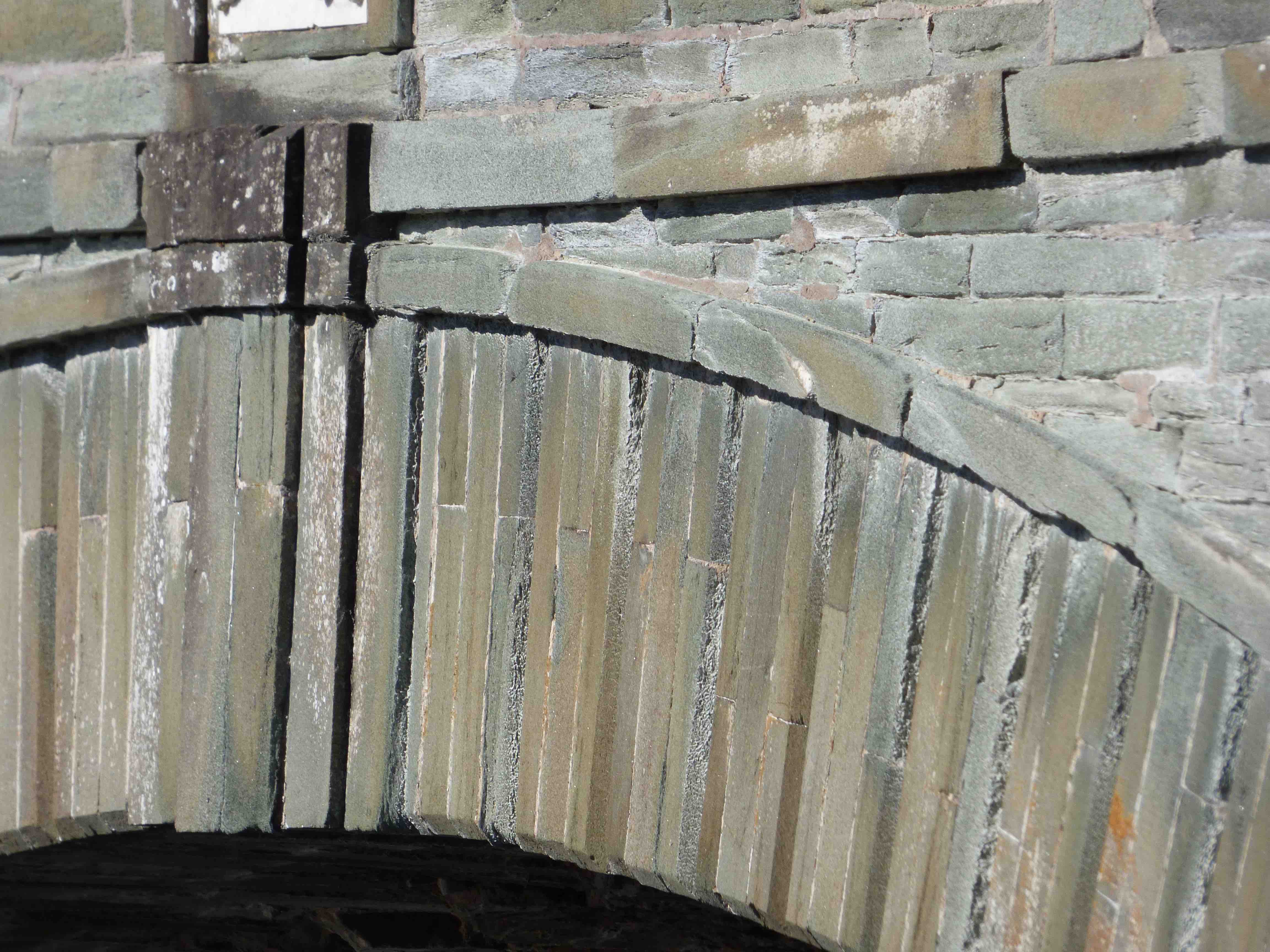
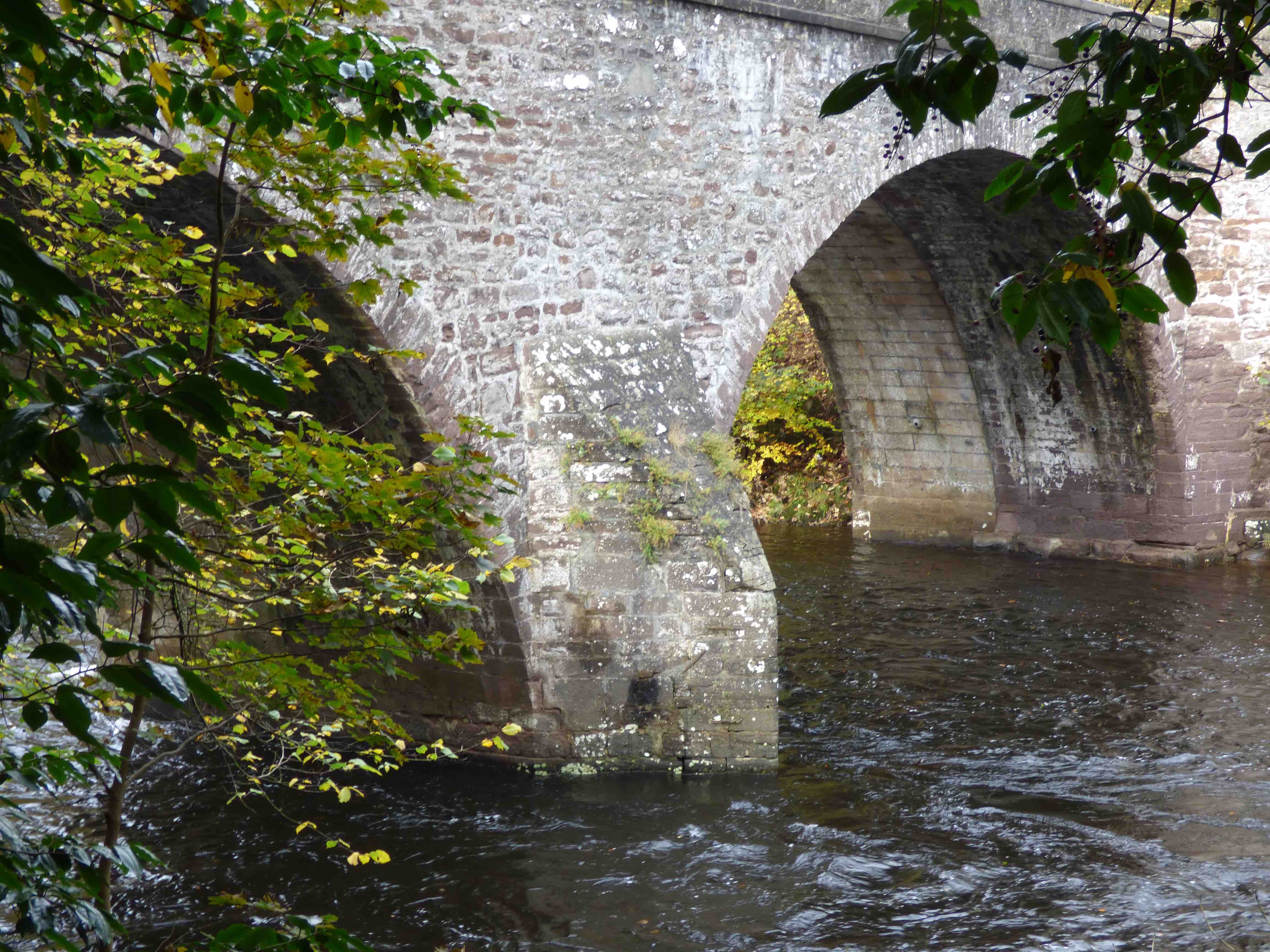
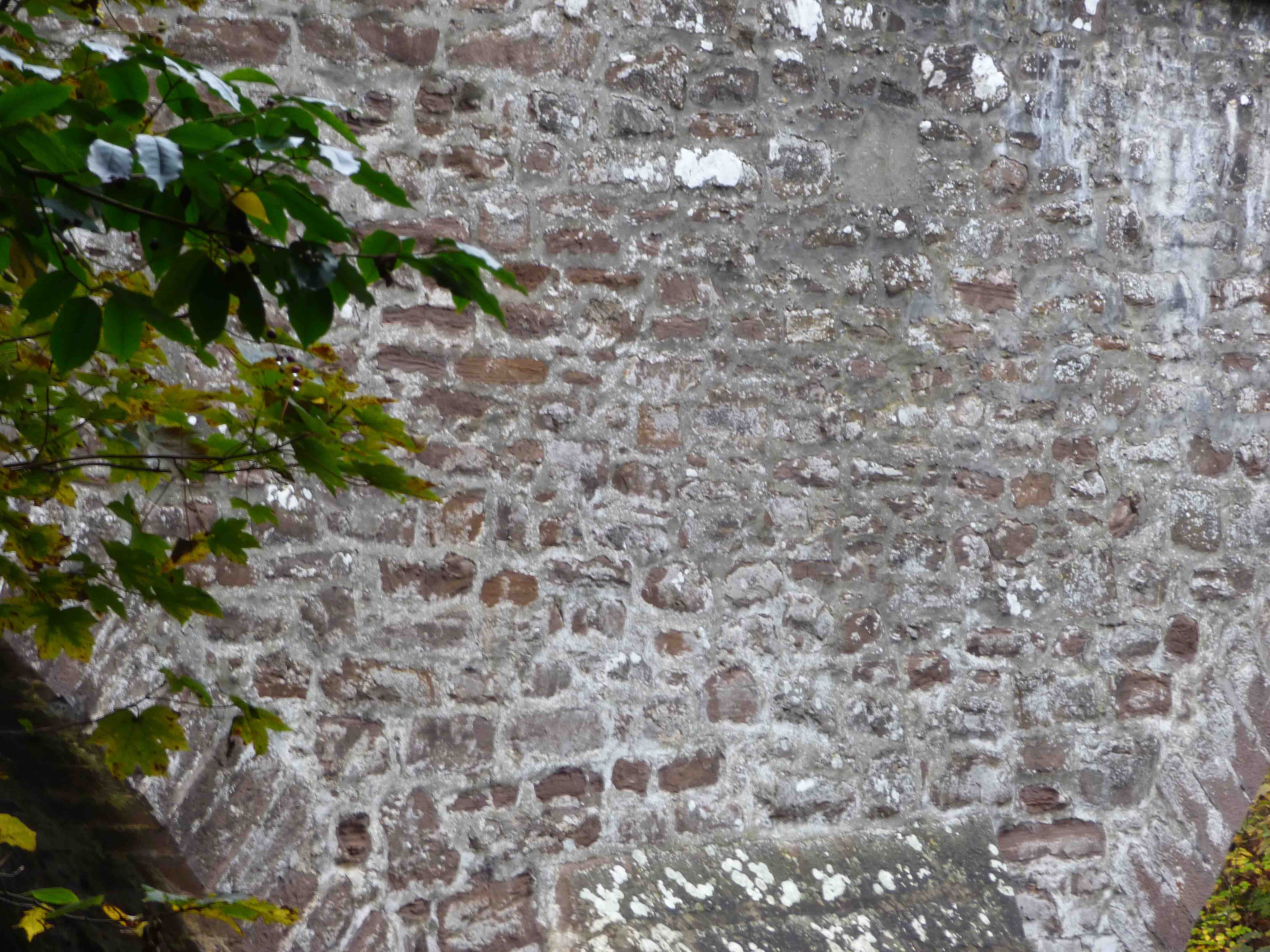
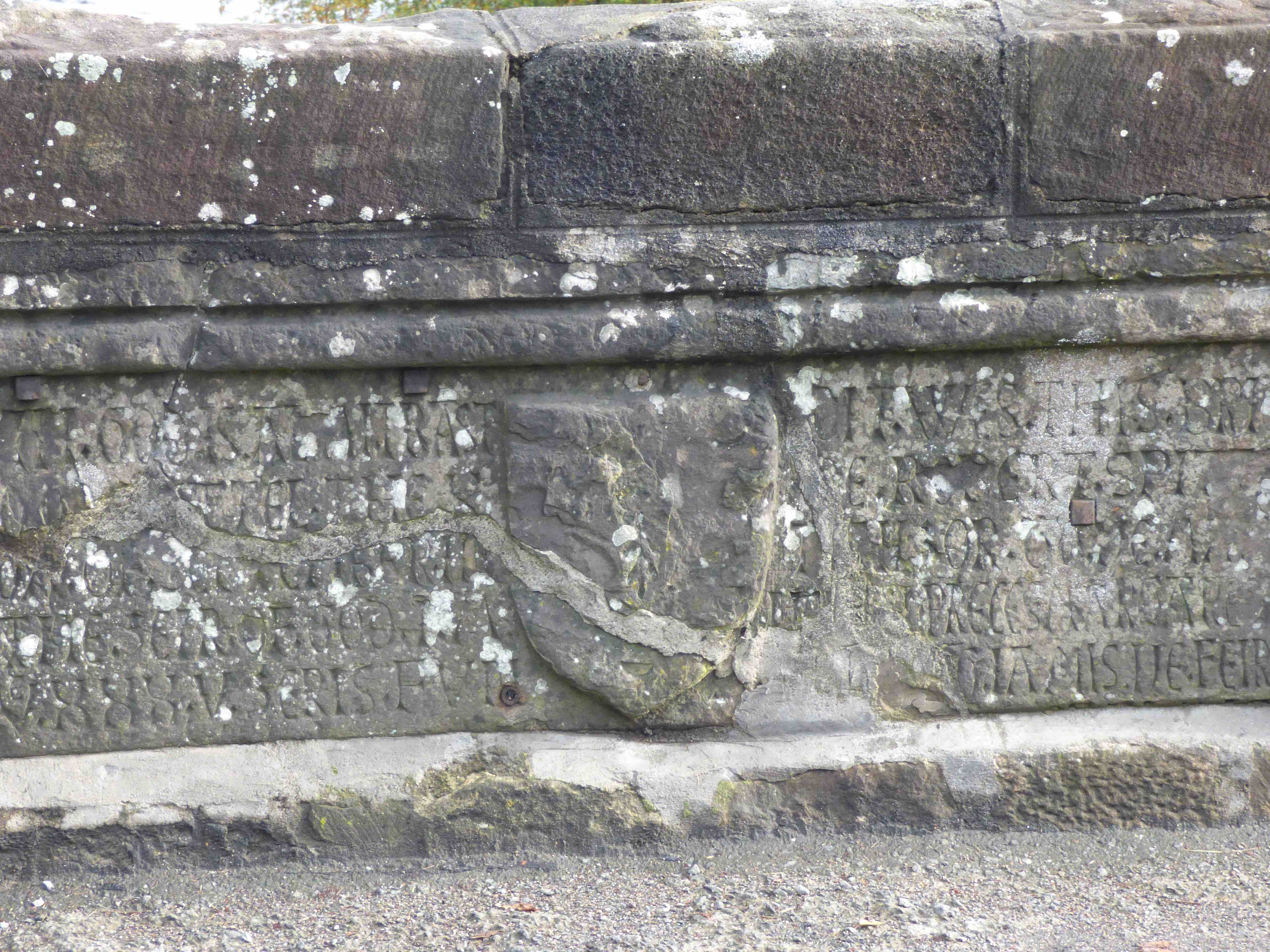
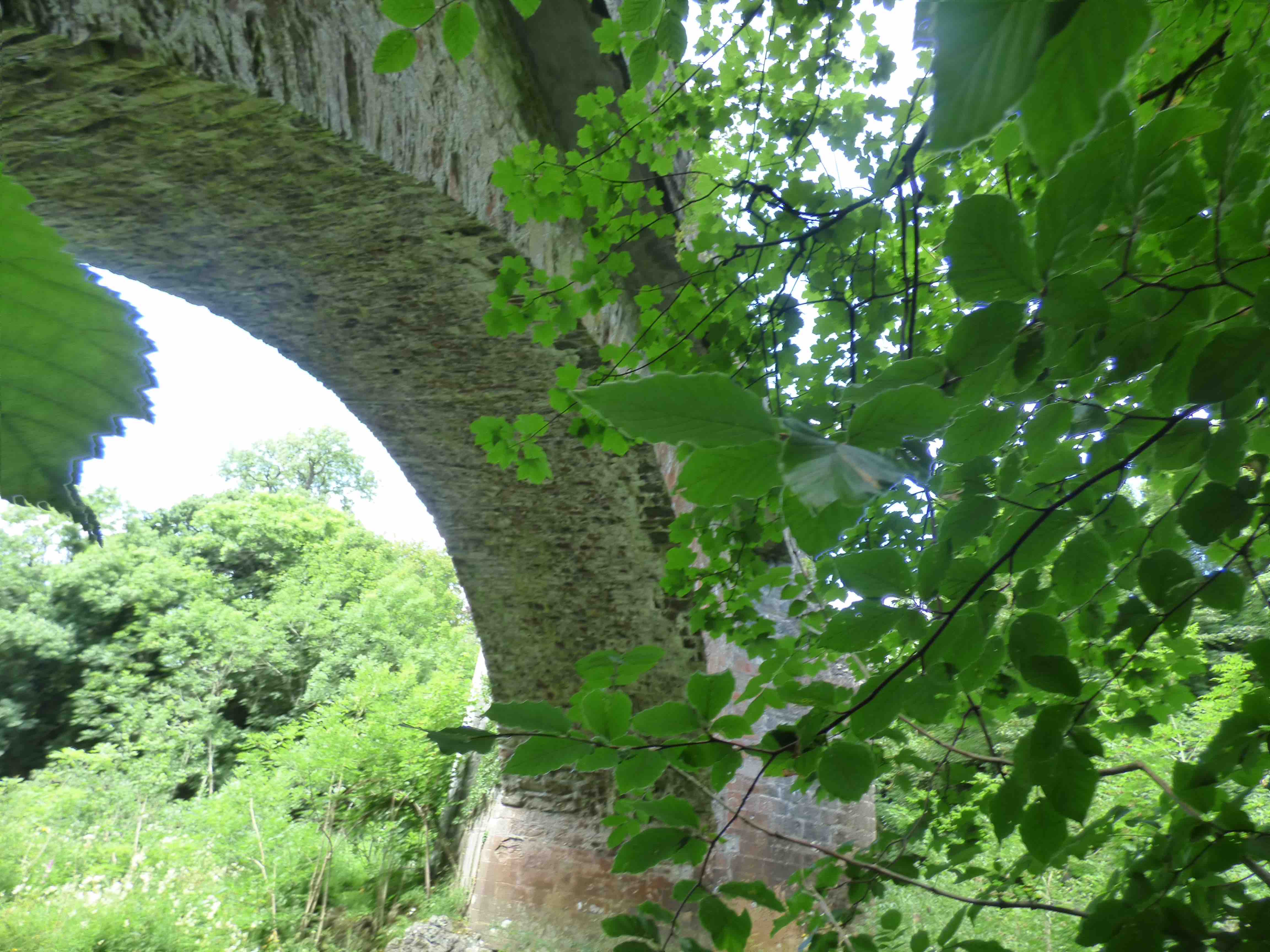
Currently: Two large semicircular arches with clear parallel widening and a younger facing on the upstream side(photo1), which has ashlar voussoirs and random rubble walls. On the older downstream facing there are dressed, un-squared, un-coursed rubble spandrels and walls (other photos) and the voussoirs are rubble and rather crude. There is no chamfering. The original width was about 10ft between the parapets (judging from the widening). Marked string course and much younger parapets in which earlier inscriptions and heraldry have been embedded. Included, is an example of twin royal arms (photo 6). The arch shape, the cutwaters and the narrow width all suggest an early date compatible with its 16th century history. However, the masonry looks firmly from the 18th century- perhaps from the time of Argyll's intervention but there is no documentation for any rebuild. This is difficult to reconcile. It was an important crossing and one might have expected it to have been widened in 1716. It is still rather narrow for two-way traffic, even after the 1866 widening. In 1740 a presbyterian secessionist church was built next to the south downstream abutment and this was rebuilt in 1832 along with a manse. The church collapsed in the 1940s and is now a ruin in the garden of the surviving manse.
photo photo photo photo photo photo photo
_______________________________________________
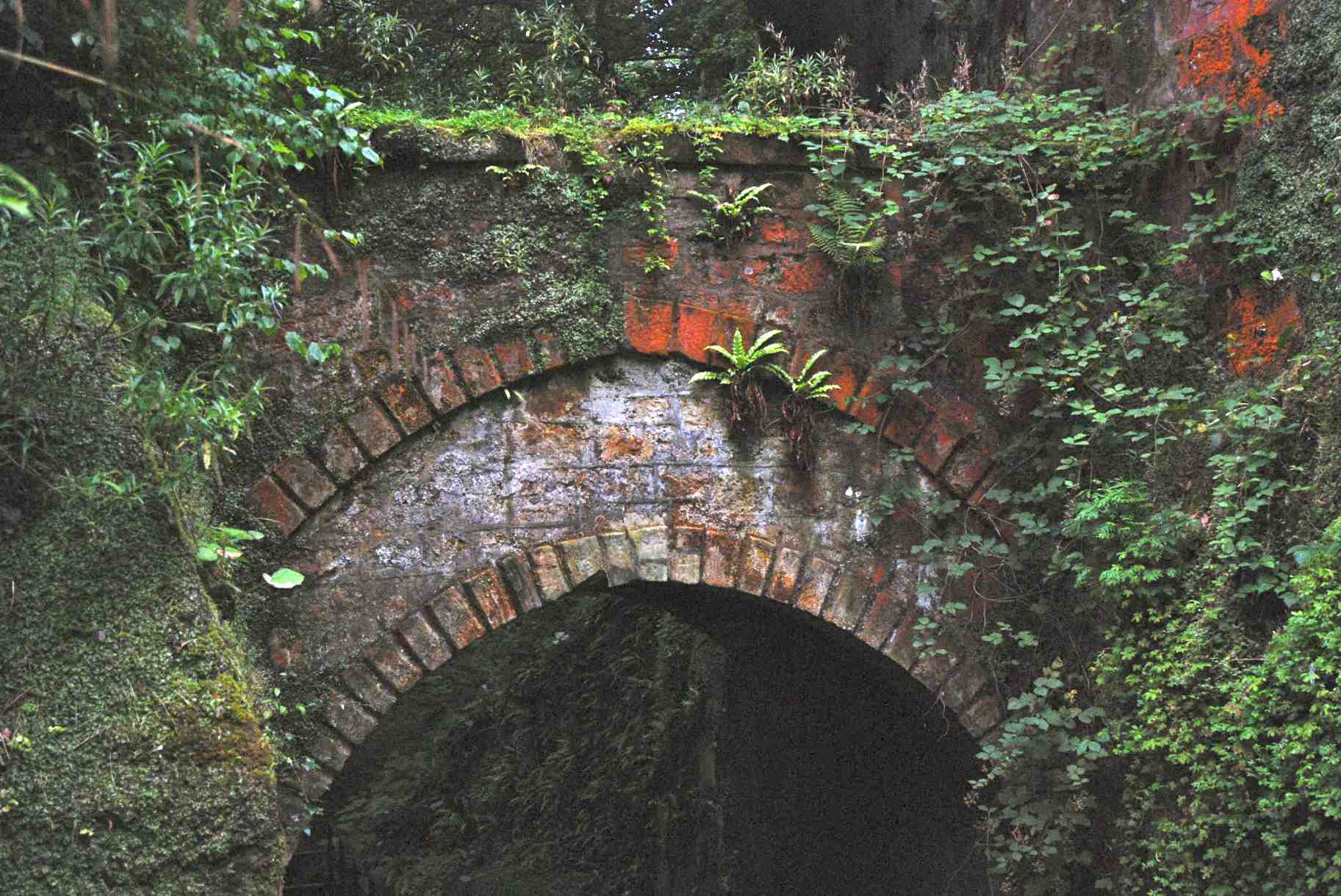
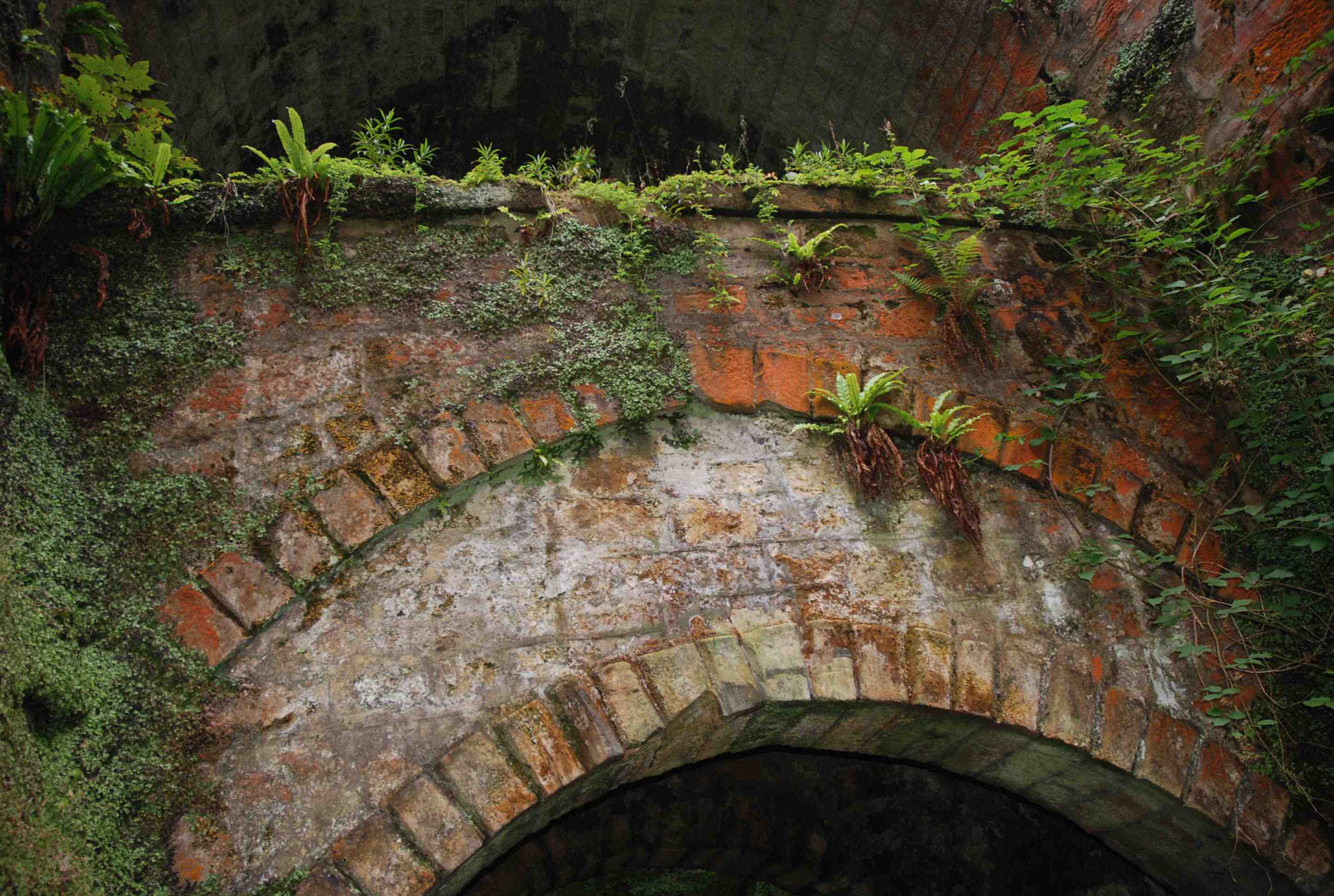
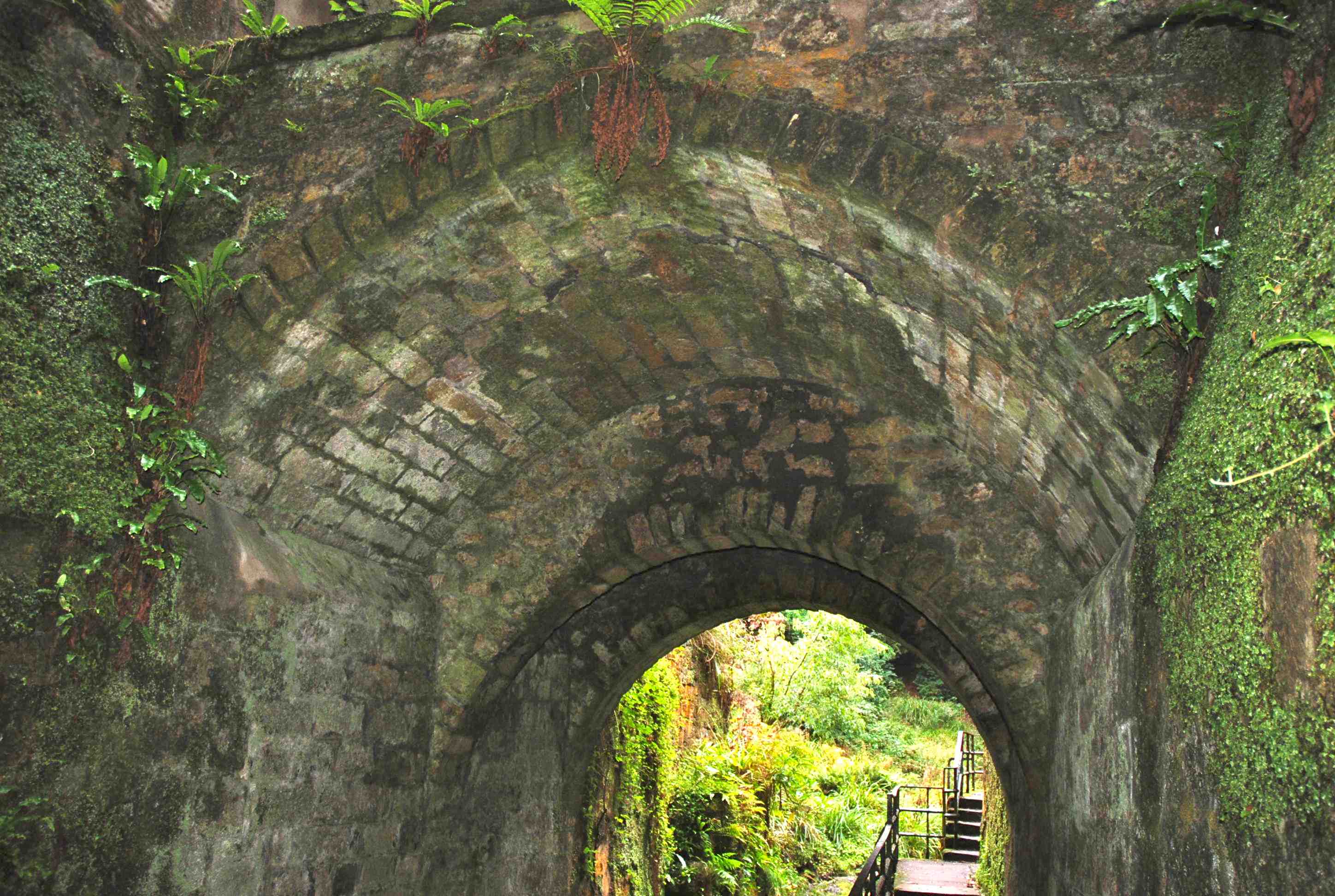
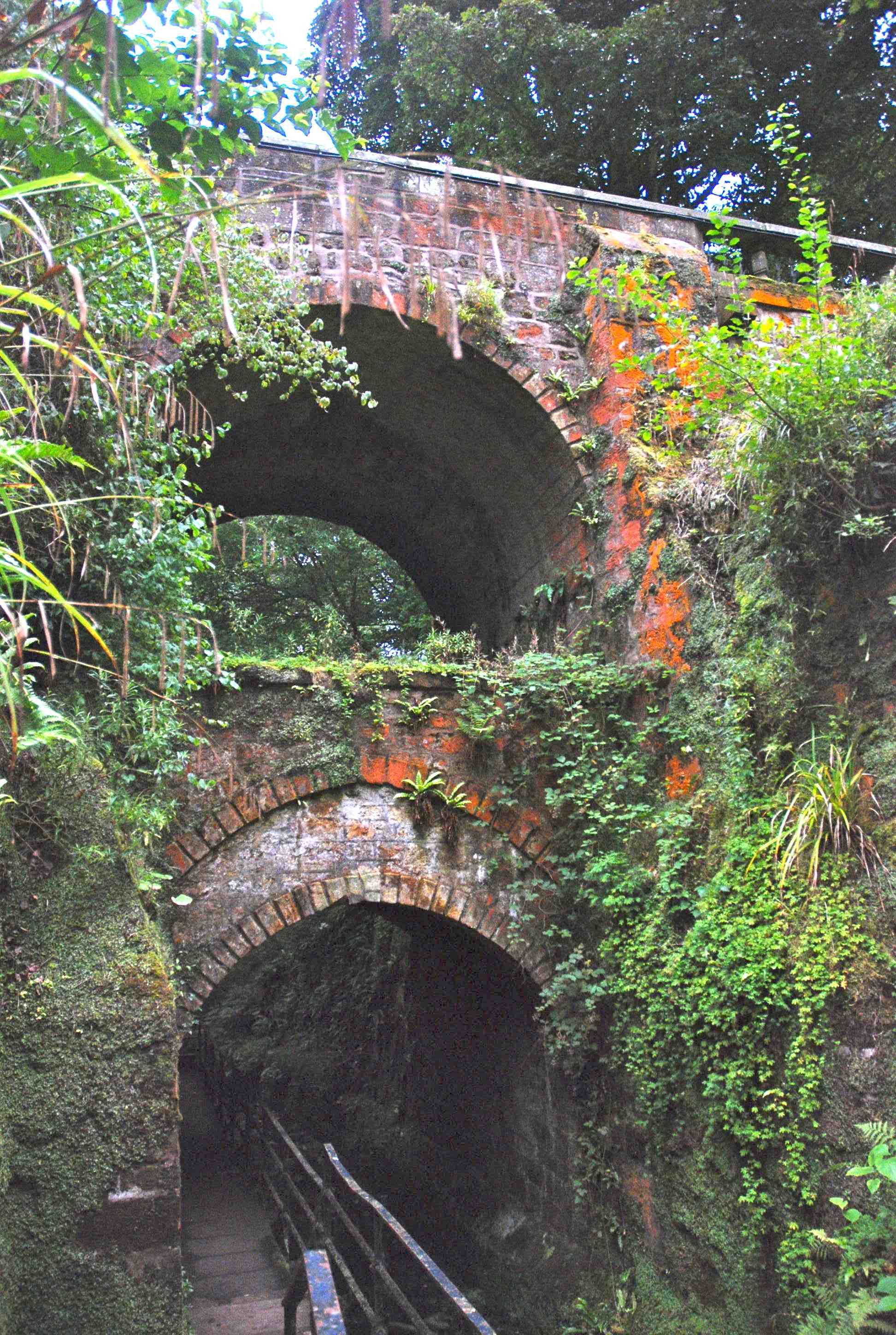
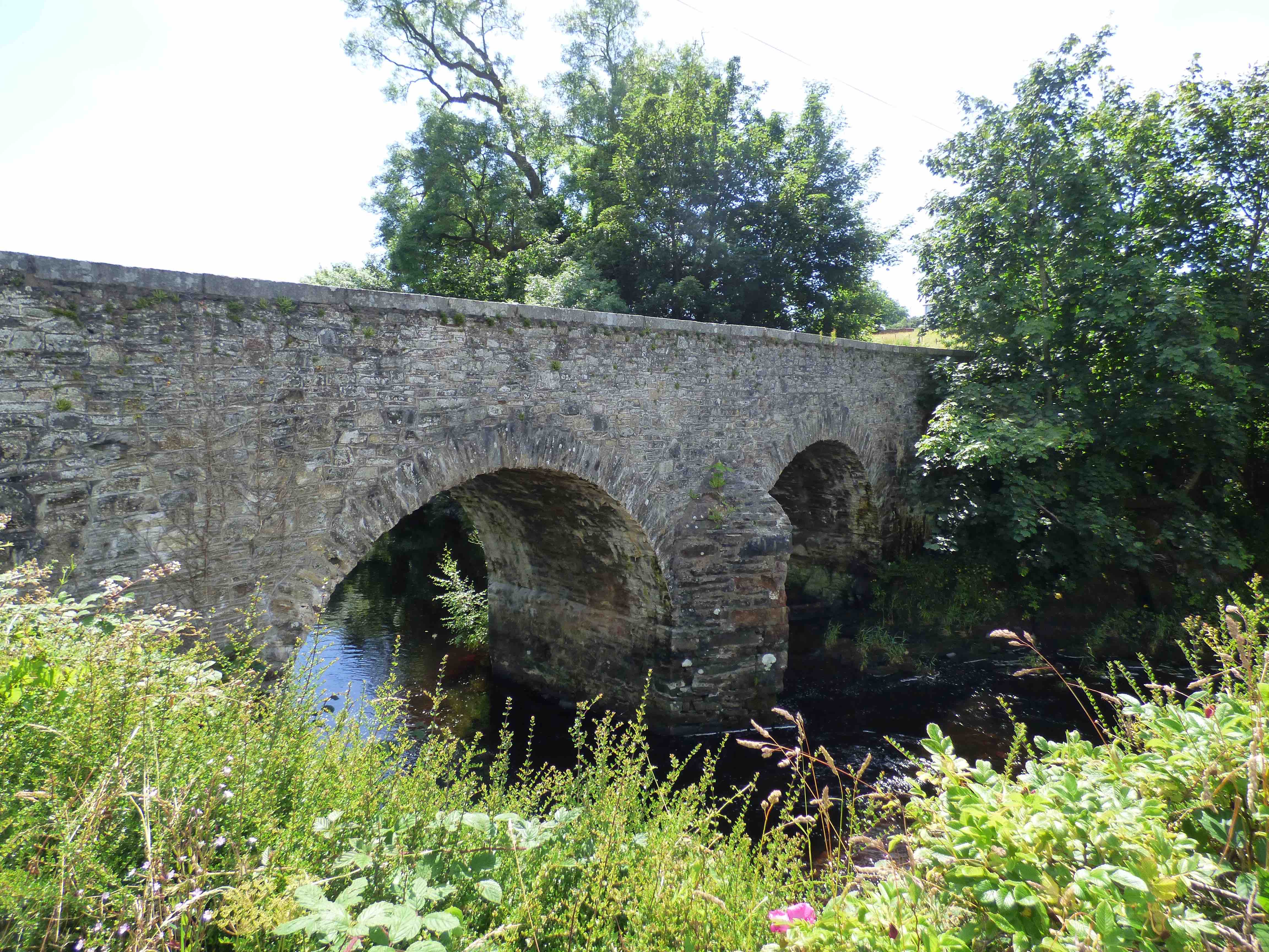
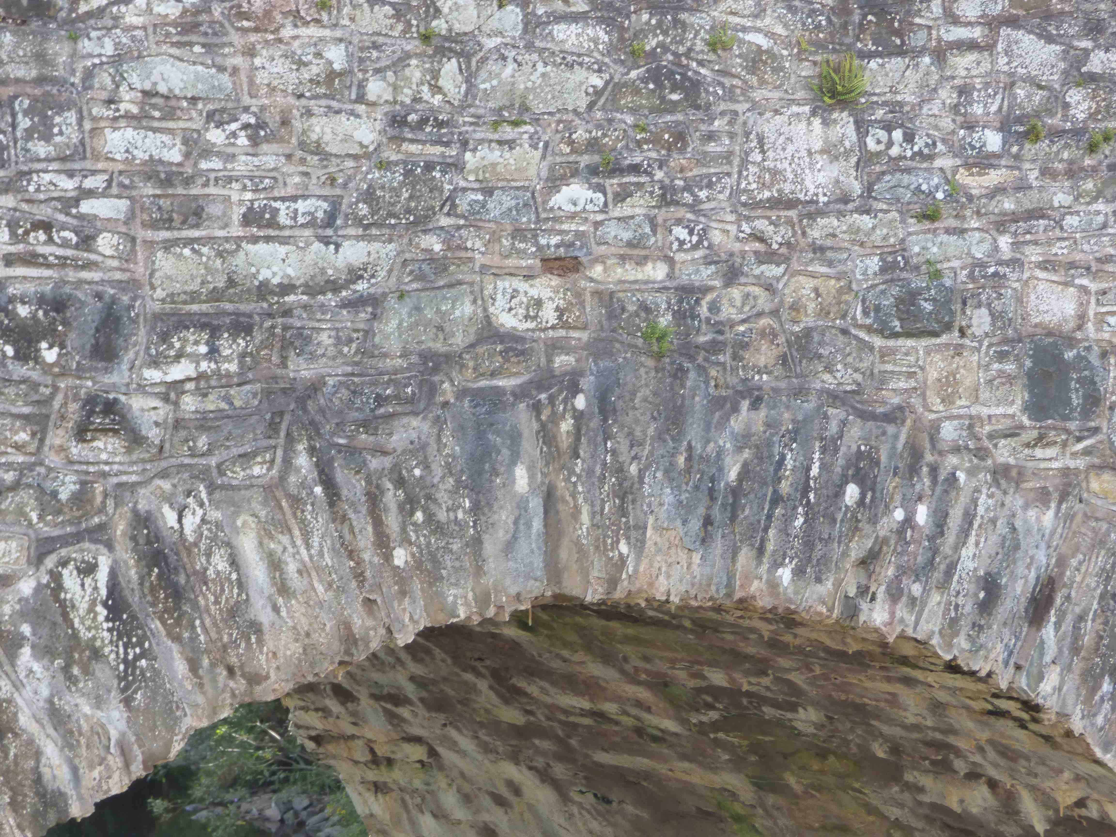
OLD TONGLAND BRIDGE Kirkcudbright
C. Dum & Gall R. Dee 269705,553651
History: Possible link to Tongland Abbey Church, of which nothing remains. Fragments of the abbey stonework have been found embedded in the bridge. NSA Kirkcudbright reports that Mary Queen of Scots crossed a wooden bridge at Tongland in her flight from Langside (1568) and pulled down the bridge behind her to prevent pursuit. The present old bridge was built in 1737. It was incorporated into the Carlisle/Portpatrick military road system in 1772, thus altering the original line of the road (1764) which previously crossed at Bridge of Dee. Bypassed in 1805 by Thomas Telford's New Tongland Bridge 500m downstream
Maps:Roy(1750)
Currently: A greatly altered 18th century bridge. Parts are well preserved. Two very high stilted segmental arches with three paired very high cutwater/ buttresses. Squared rubble brought to course and rubble voussoirs. Ten ft. wide original width. Now has cantilevered widening of the decking on both sides. Extensive strengthening of the abutments and central pier on the downstream side.
Link photo photo.
_______________________________________________
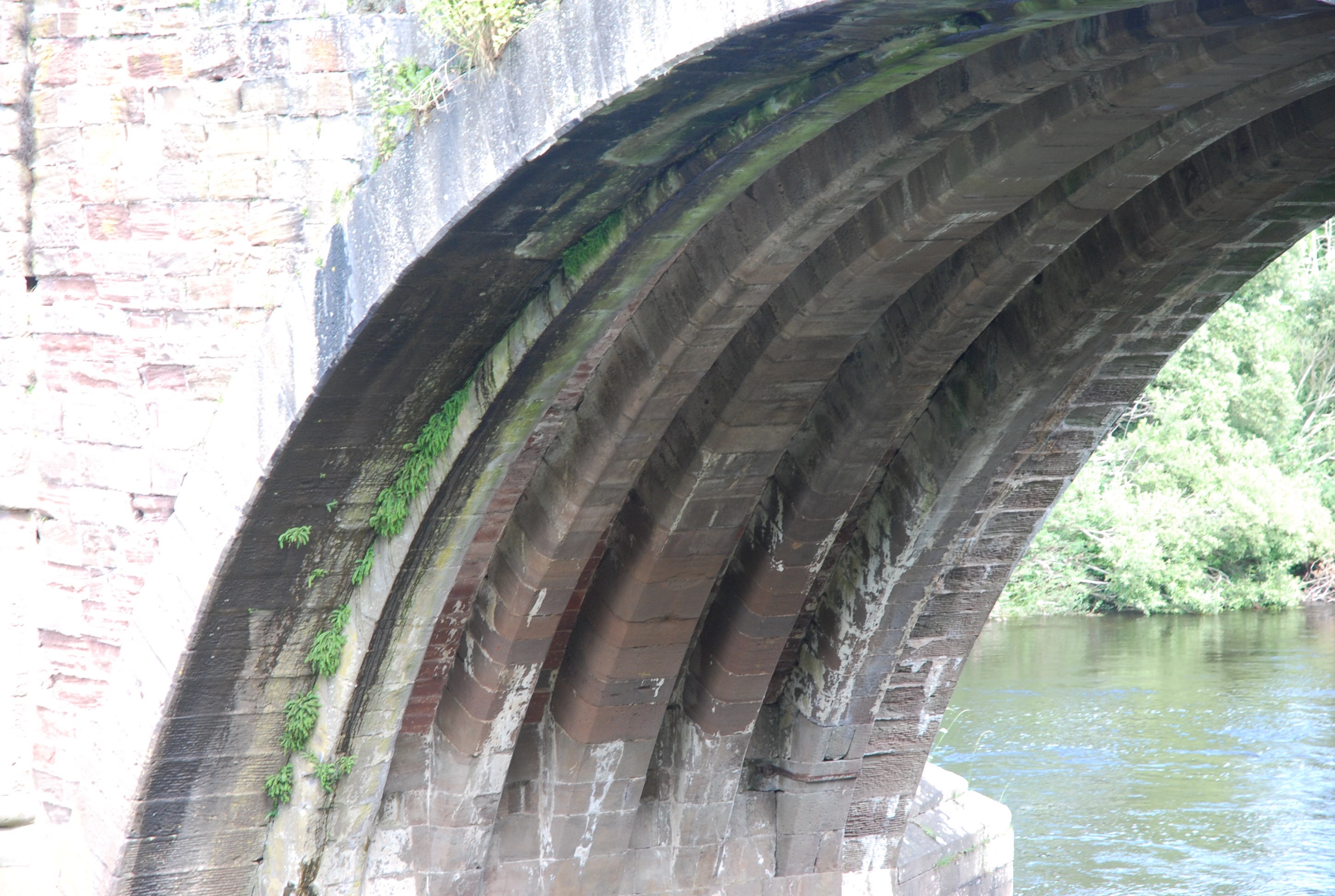
TOWER BRIDGE Dunfermline
C.Fife Tower Burn 308726,687279
History: Adjacent to Malcom Canmore's tower and close to the Medieval abbey. This is probably the bridge referred to as 'Gyrth-Bow' in the time of David I (14th C. Reg. of Dunfermline Charter 433) connecting the two communities of Dunfermline. OSA refers to 'Malcolm's Bridge' the highest part having recently been built by a Mr.Chalmers-"a work of great labour and expense.". Parapets were rebuilt in 1915.
Maps:Roy(1750) Blaeu (1640) depicts a very compact but split Dunfermline (see map below)
Currently: The existing semicircular double arched (one above the other) bridge has a lower portion from 1611 ( commissioned by Queen Anne: datestone) and an upper part from 1788 (plaque). The earlier portion was a 'Collection' period bridge 9 ft wide: later underpinned by two large ribs which appear as the lowest of three arches. At the same time the low bridge was widened to 17ft. Reinforcement is very similar to Newmills nearby. So in total there are three arches. The upper 18th century portion has copied the rusticated voussoirs from the earlier period. Coursed squared sandstone spandrels, especially well finished in the lowest arch: possibly weathered ashlar. Balustrades. Well engineered buttressing. No medieval remains here, however.
Link early-sketch map photo photo photo photo.
_______________________________________________
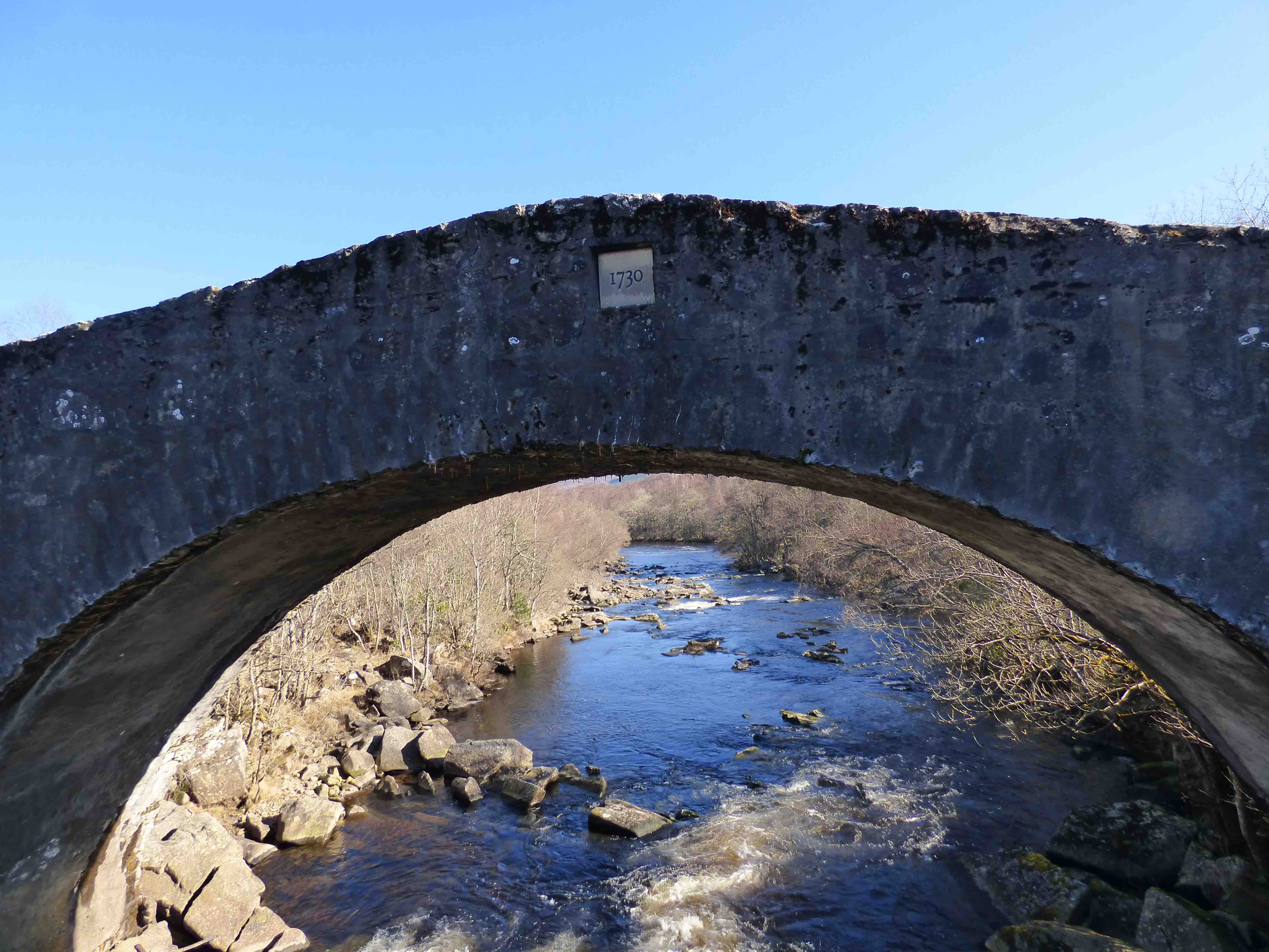
TRINAFOUR BRIDGE nr. Blair Atholl
C.Perth Erochty Water 272504,764711
History:Military bridge. Wade: Crieff to Dalnacardoch road. 1730. The approaching military road can be seen (photo4). There was also a Kingshouse built at the time of the old road.
Maps:1750
Currently:18th C , though widened on the upstream side from about 9ft to 21 ft. This widening was from the parliamentary period (around 1810) and the characteristic plumb and batter buttressing can be seen. The arch is almost semicircular. Parapets are sloping. The voussoirs appear to be whinstone. There is more recent iron pattress plating. Un-coursed partially dressed rubble and some random rubble.
photo photo photo photo
_______________________________________________
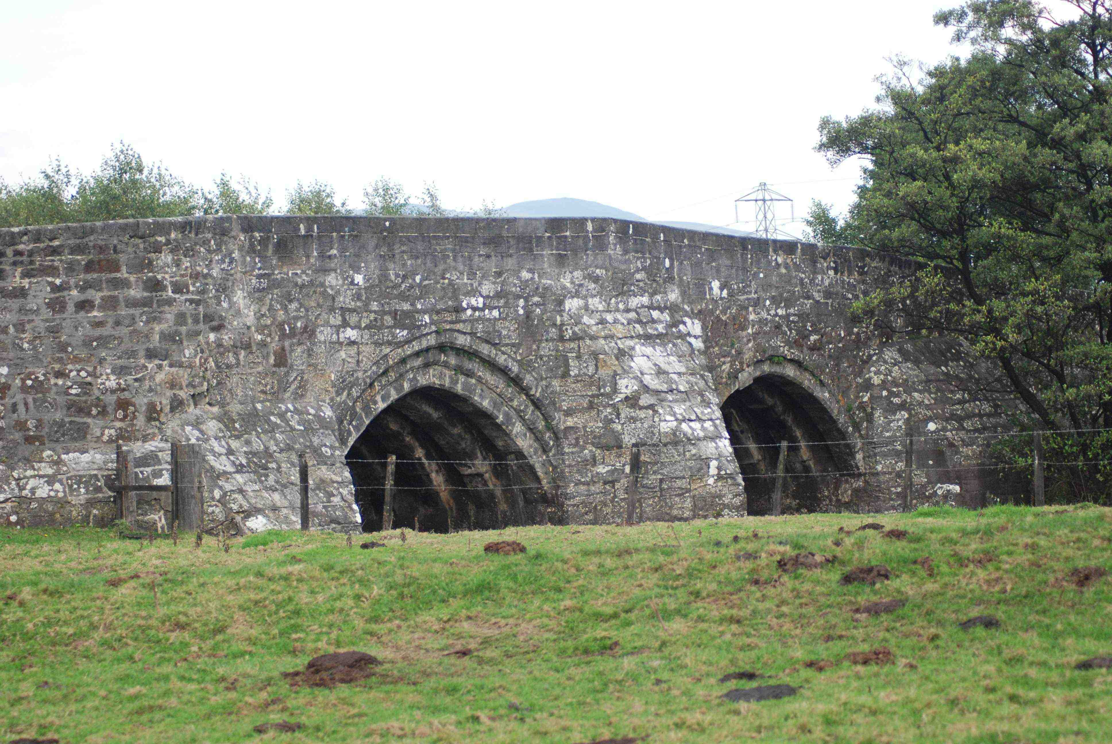
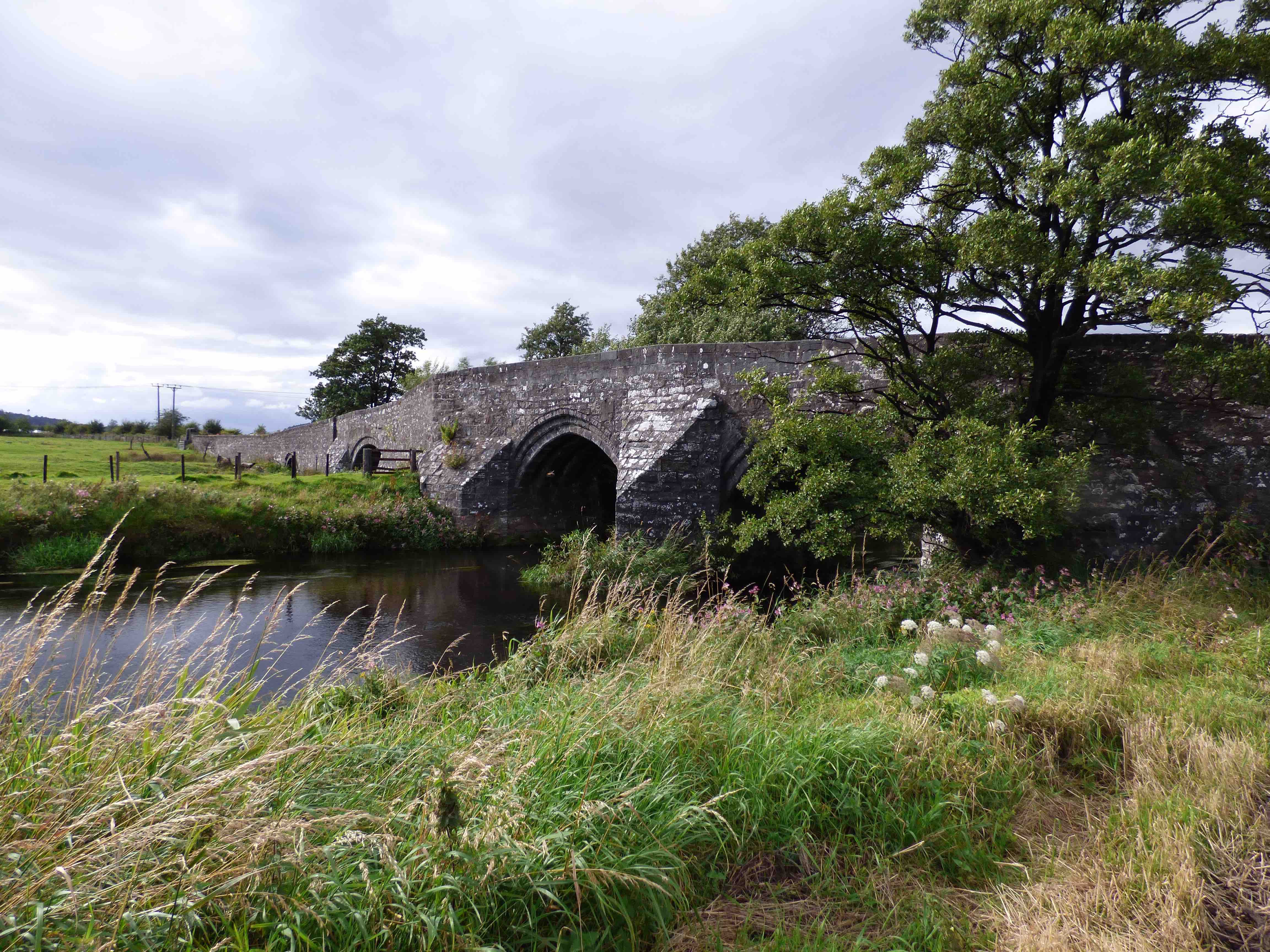
TULLIBODY BRIDGE
C.Clackmannan R.Devon 284652,695135
History: Reputedly built by Robert Spittal in 1520, who also sponsored Bannockburn and Doune bridges. In 1560, Scots troops collapsed the west arch to delay the retreat of the French (Mary of Guise troops), going from Leith to Stirling. The breach was repaired by the French, from the roof of the Auld Kirk. Further major repairs in 1596 (a Stirling Charter) and in 1616. Parliament granted a levy in 1675 for extensive work, done in 1697.
Maps: Roy(1750) Adair (1680s)
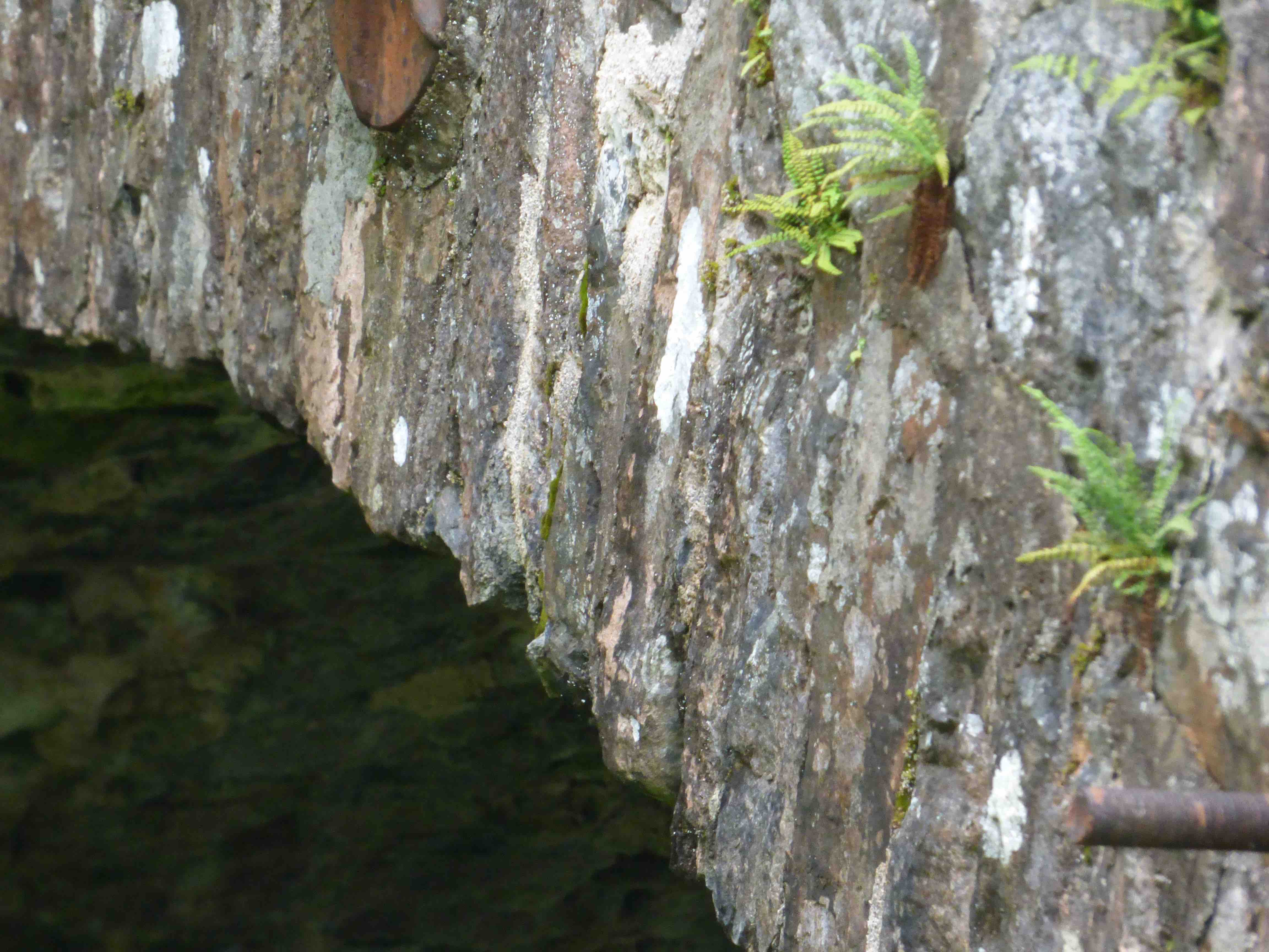
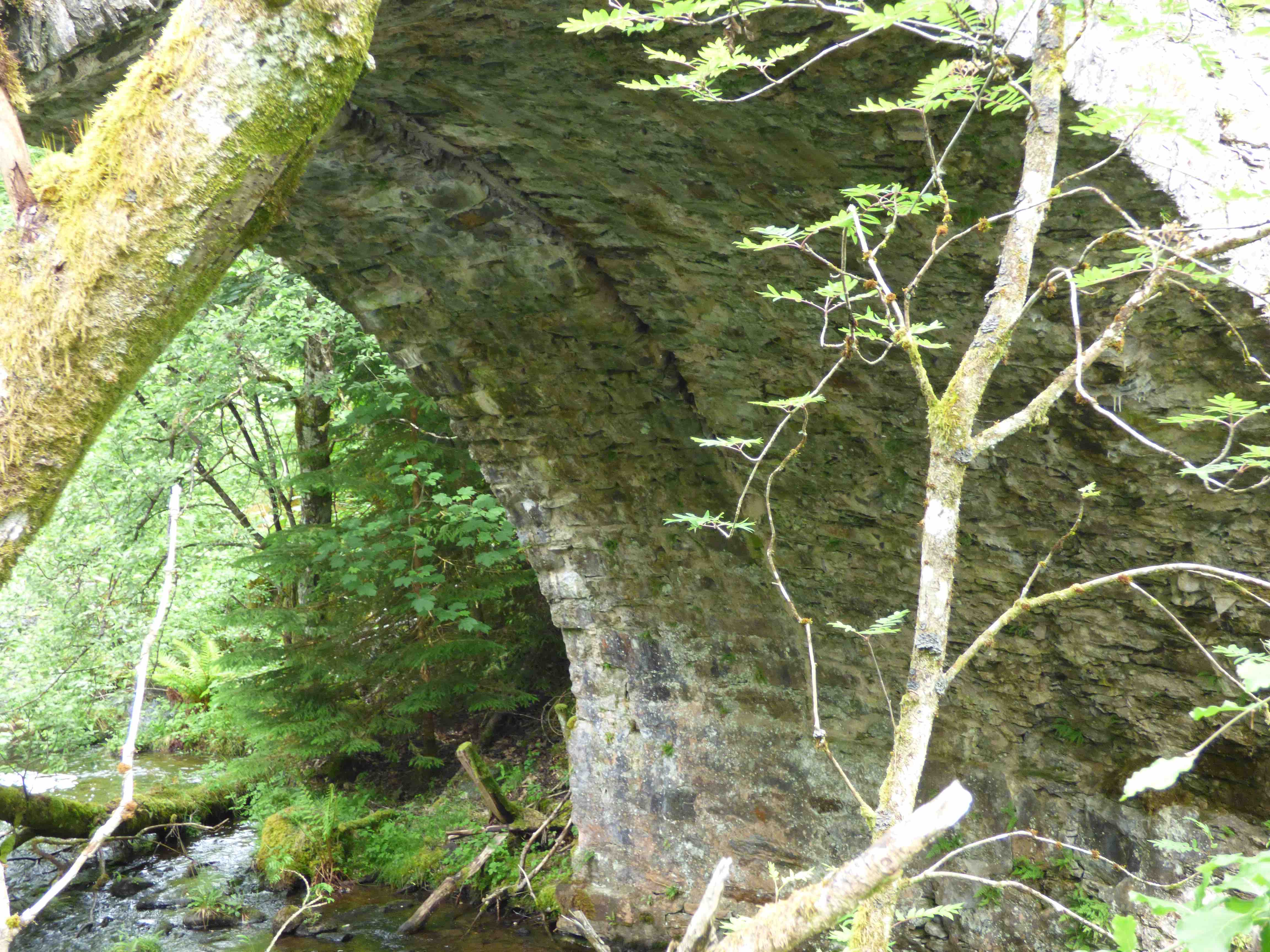
Currently: Two small ribbed stilted gothic arches of 18ft.span. Four ribs each. One arch has two orders of chamfered voussoir, which almost gives the impression of archivolting. Long approaches are well designed with three small semicircular flood arches. These are of a later date: perhaps 1697. Coursed squared rubble spandrels and in some parts, possibly weathered ashlar. The western arch is the younger, damaged one. Fortified twist to deter charging horsemen. The central portion which crosses the river is the oldest section. The spans are 18ft which seems unnecessarily small for a 1520 date; a single, larger (45ft) arch without a pier might be expected. Width is 11ft. These small gothic spans suggest a 15th century date. Worth noting that the link to Robert Spittal is by tradition only. However, there is no mention of the bridge in the charters of Cambuskenneth Abbey.
Link photo photo photo photo photo.
_______________________________________________
TUMMEL BRIDGE (Kinnachen or Cannaghan Bridge)
C. Perth R.Tummel 276249,759189
History: 1733 military road. Wade. Crieff to Dalnacardoch road. The work was contracted out to John Stewart of Canagan. Known earlier as Canagan Bridge. The Kynachan estate is now a Forrestry park. Mr Stewart was paid £200 but contracted to maintain the bridge for 20 years, at his own expense. The contract papers still exist.
Maps:1750
Currently:1733
One segmental arch, 55ft + 1 flood arch, 11 ft wide. Enormous single buttress on upstream side. Very markedly humped. Random un-coursed, but well faced rubble on upper parts. Lower spandrels have some rough coursed and squared rubble. Voussoirs in rubble. Appears to be semi-harled. Cramping. The brass plate with 1730 date is a little early. A Kings-house from the same period is adjacent.
This is not a typical Wade bridge - perhaps reflects a subcontractor.-Only a few of his bridges were actually built by the army. This one is more humped and better built than usual.
Link photo photo.
_______________________________________________
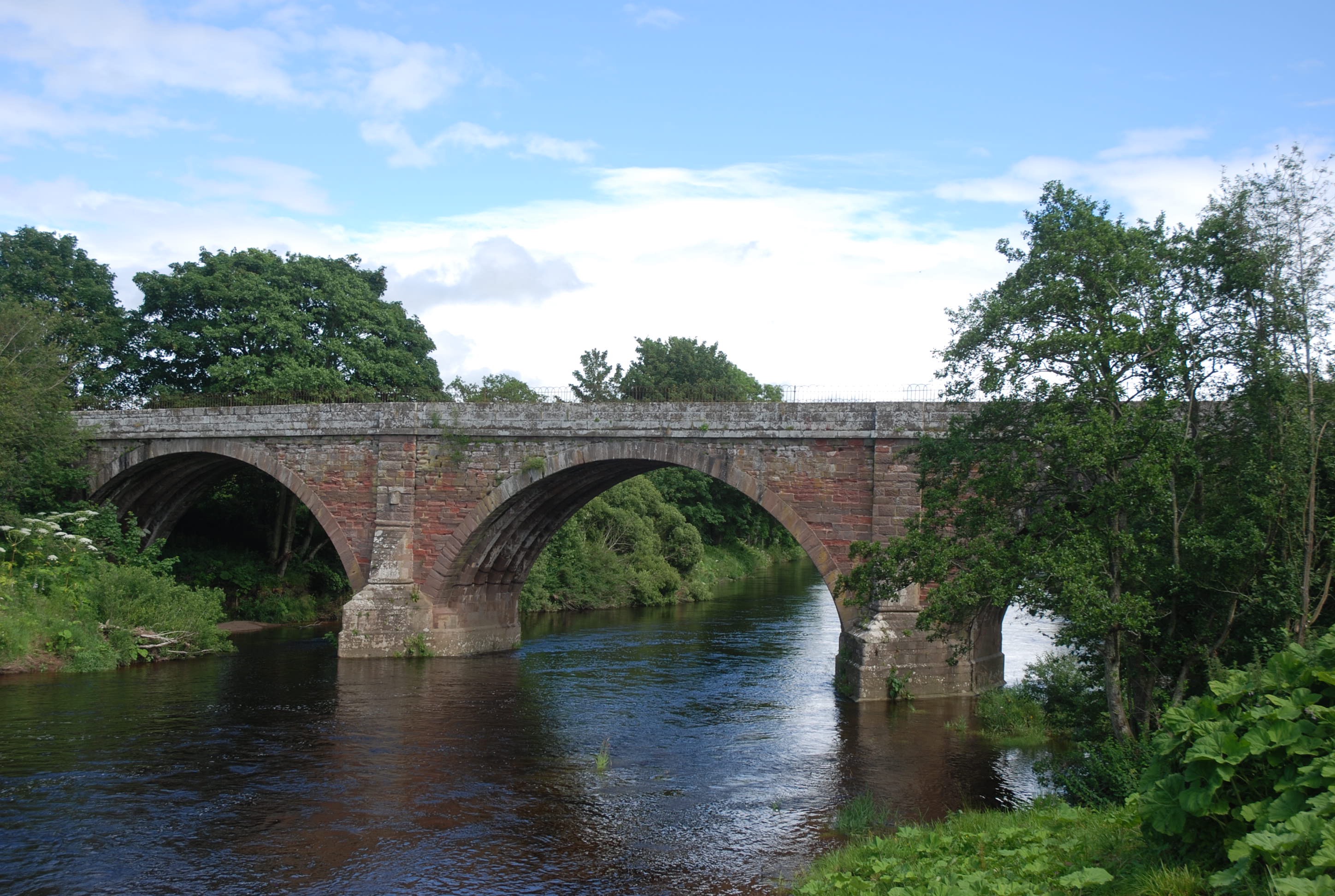
UPPER NORTH WATER BRIDGE Inglismaldie
C.Forfar North Esk 365273,766135
History: Written date 1539 (Inglis). Toll imposed for upkeep in 1669 after very major repairs. Widened in 1800 and major repair/restructuring in 1841. Used to carry the main Dundee Aberdeen Road.
OSA Logie-Pert (1790). Rev.Peter records that the bridge was built '200 years ago' by a John Erskine of Dun in response to a dream which threatened a miserable after-death.' He took three attempts to build it. Other authors attribute the bridge to Bishop Dunbar , which implies a slightly earlier date of 1520. Thomas Franche would have been master-mason.
Currently:16th C.
Three 50ft almost semicircular five-ribbed arches. 12ft wide. Widened mid 19th century by John Gibb.
Coursed well dressed squared rubble spandrels; in some parts possibly very weathered ashlar. Decaying heraldic plaque on downstream side. Although the masonry is very weathered, the ashlar voussoirs are of very high quality for a bridge of this period and it may be that much of the masonry dates from the 17th century. There are some style similarities with Dee Bridge in Aberdeen (also Bishop Dunbar), in particular the 5 dressed stone square ribbed arches.
(Worth noting here that a few km away is -probable location of two bridges identified in Arbroath Charters from early 13th century)
photo photo photo photo.
_______________________________________________
OLD BRIDGE OF URR Castle Douglas
C. Dum & Gall Urr Water 277603,567723
History:This old bridge has a date stone on the south- facing which is now indecipherable but creditably gave a 1580 date. The heraldry of Scottish kings was reputed to inscribed along with 'JR', Jacobus Rex. Was James VI instrumental in its construction? The bridge appears on Pont (1640) which appears to be confirmation. Another date panel on the south parapet reads 1815. It is known to have been repaired in 1728 and widened in 1772 . It was a mill bridge and the mill is adjacent. In one of the later reconstructions, it is thought that stones from the ruined Buittle Castle were used.
Maps:Roy(1750) Adair (1680s) Blaeu(1640)
Currently: Apart from the panels on the south facing it is difficult to see anything from the 16th century. Two semicircular rubble arches without ribbing. Spandrels in well dressed, very roughly squared rubble which is brought to course. This all fits with an 18th century date. The parapets are probably from the 1815 date. The widening can be seen. Now 13ft wide p to p. Earlier width was 10ft.
After some thought it has been given a maroon marker rather than a red one. This is really a very 18th century structure. It was common practice to transplant panels through repairs and rebuilds.
Link photo photo photo.
_______________________________________________
WEST BRIDGE Cullen see CULLEN HOUSE
_______________________________________________
WHITE BRIDGE (Cawdor) see CLEPHANTON
_______________________________________________
WHITE BRIDGE Foyers
C.Inverness R.Foyers 248917,815370
History:1732 Wade military bridge. Ft.William Inverness Road. Roy describes this a 'Six Mile Bridge' Cost £150 to build. Seriously damaged in floods of 1829..."in a very singular manner-the outside walls and parapets were left entire while the roadway arch all within totally disappeared" (Dick Laird).
Maps:1750 but also probable location of a Pont bridge (1600). Difficult to locate on Pont.
Currently:1830 complete rebuild in 18th century style, in random un-coursed rubble, except for the arch which is in ashlar. Worn date-stone preserved. Marked string. Single semicircular 40ft arch with sandstone decorative voussoirs. Nine ft. wide. Adjacent bypass bridge is 1932, though the 18th century facings have been preserved.
photo photo photo.
_______________________________________________
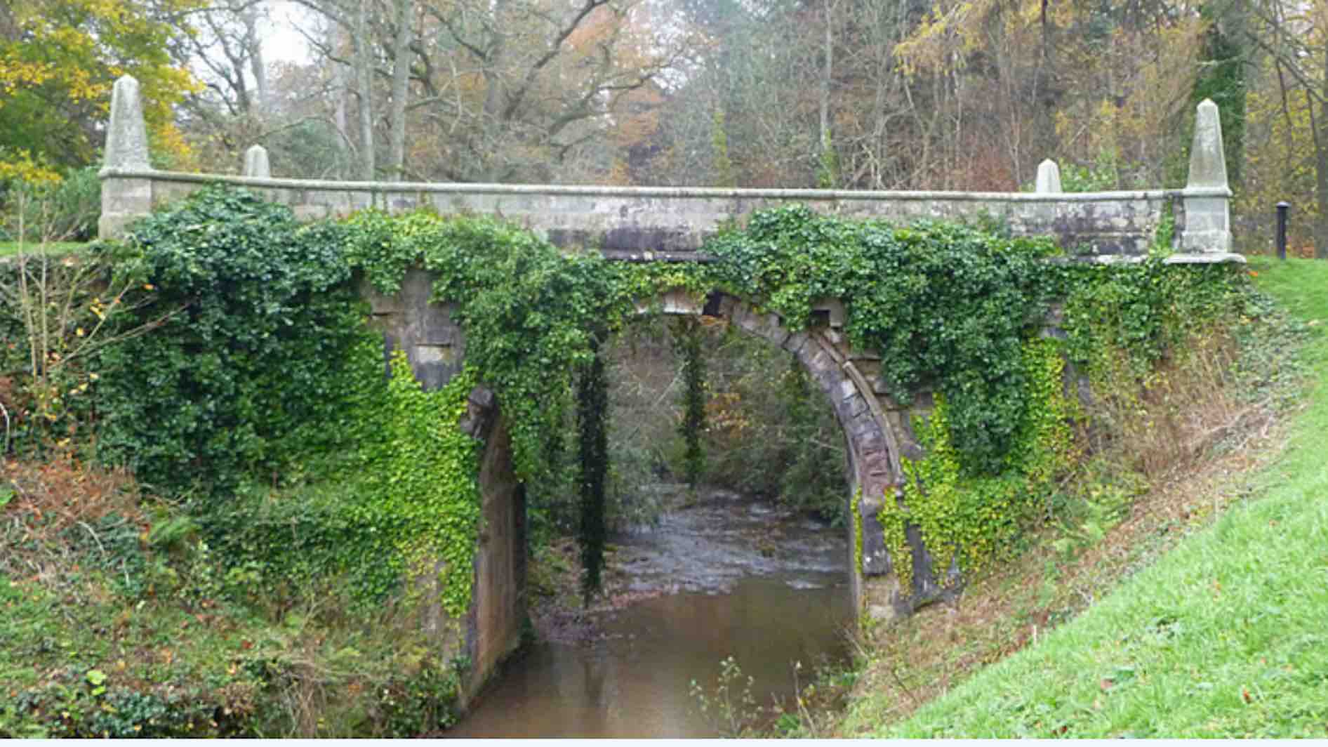
YESTER BRIDGE Gifford
C.Lothian Gifford water 354141,667344
History: This is probably the location of the Bowbriggis of Bothanis identified in charter No.1051 (dated 1580) in the Yesterwrits. Bothans (Yester) was a very ancient settlement. The present bridge dates from 1744 - a William Adam classic - similar in ways to the Aberfeldy Bridge which he designed for General Wade. However, it is also in Adair(1680s) which suggests a previous exixtence.
Maps:Roy(1750), but unusual depiction. Adair (1680). Not on Blaeu.
Currently: A beautiful estate bridge (Yester House was also built by Adam). Single span raised semicircular arch with a horizontal decking. Strong string course and arch hood-mould. Obelisks at the quadrants. Squared well dressed rubble spandrels brought to course. Rubble voussoirs.